Close the Gap: Transportation Investments to Support Our Region’s Growth
by Mike Helgerson, MPA
Executive Director, Metropolitan Area Planning Agency (MAPA)
AUGUST 2017: As part of its Heartland 2050 Regional Vision, Metropolitan Area Planning Agency (MAPA) has been leading a conversation in the Omaha-Council Bluffs metro about the importance of investing in a regional transit system. In the summer of 2016, the Heartland 2050 Executive Committee endorsed the “Close the Gap” Plan as the project’s “big idea,” or primary focus area.
The Close the Gap Plan recommends creating vibrant places that are more livable and walkable, which are connected better through a robust regional transit network that connects residents to jobs, education, and other destinations. Experiences from other regions indicate that such an investment has the potential to yield a transformative impact on development patterns and opportunities for economic growth.
By 2050 we anticipate that the region will grow to more than 1.25 million residents. Without considering our land use and transportation decisions together, our growth will likely occur mainly in development patterns conducive solely to automobiles. With this type of development pattern, our communities and residents will be forced to support increasingly expensive infrastructure. We will walk less, drive more, and experience more congestion on our roadways.
Investments like a modern streetcar can reshape urban corridors and foster walkable, vibrant communities that support active lifestyles for young and old alike. This type of strategy is an important example of how we can balance our region’s long-term growth with the quality of life that residents desire.
Where We Grow Matters
The metro area has enjoyed healthy economic growth in recent decades. Increasingly, jobs are heading to suburban locations, which can be difficult for unemployed and underemployed persons to access. As part of a regional transit system, a modern streetcar, will mean more destinations, more jobs, and more places to live in the urban core.
A market analysis conducted for the Central Omaha Alternatives Analysis (the study that led to identification of the current Bus Rapid Transit and Streetcar projects) showed that the area could attract as many as 20,000 new jobs in the Downtown and Midtown area if parking was managed better. This would be a dramatic change, as Downtown Omaha has lost 21,000 jobs since 1963–employment opportunities that were once in close proximity to low-to-moderate income neighborhoods in the urban core on both sides of the river.
While this transformation can reshape our urban core, the Close the Gap Plan calls for investment in several key transit corridors with faster, more frequent service, technology to make transit faster and more convenient, and permanent transit infrastructure. Many of these corridors build on previous plans, and connect the region’s job and entertainment centers, community colleges and universities in all corners of the region. While these proposals are in the conceptual phase and will continue to be evaluated, they provide a glimpse of the impact that a regional transit system could make in our region.
Our Priority Corridors
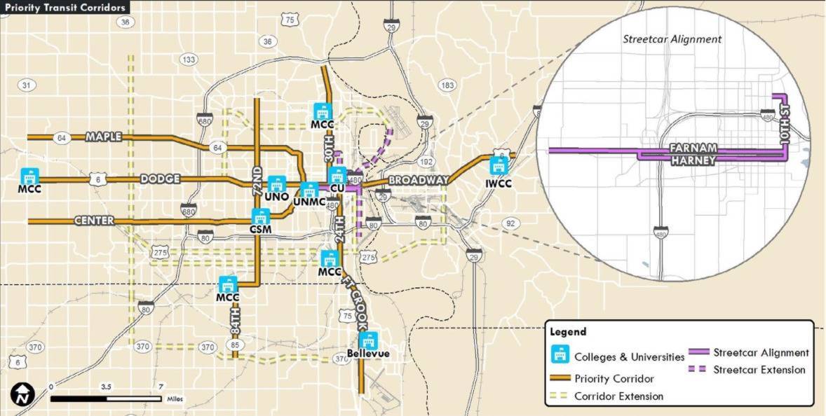
East-West Regional Spine
Dodge – Broadway
This corridor runs from Metro Community College (MCC) in Elkhorn on the west to Iowa Western Community College on the east. This extends Metro’s Bus Rapid Transit (BRT) project that will run along the Dodge corridor from Westroads to Downtown Omaha. Currently, Metro provides bus service on this corridor with Route 2, Blue-Yellow Routes, and Route 92 Dodge Express in the peak hour.
North-South Regional Spine
30th – 24th – Fort Crook
This corridor runs from Florence on the north to Offutt Air Force Base on the south. It provides connections to MCC’s Fort Omaha Campus, North Omaha, Creighton University, Downtown Omaha, Metro Omaha South Omaha Campus and South Omaha, Bellevue University and Offutt. Currently, Metro provides bus service on this corridor with Routes 30, 24, and Route 95 Bellevue Express in the peak hour.
Downtown to UNMC Streetcar
The streetcar provides an important economic development and mobility connection, and would connect North Downtown to UNMC along Farnam or Harney Streets. Potential expansions include connections to Henry Doorly Zoo, Eppley Airfield, and North Omaha. Currently, Metro provides bus service on this corridor with Route 15.
72nd & 84th Street Corridor
This runs from Immanuel Medical Center on the north to Midlands Hospital on the south. It connects the 72nd Street employment corridor, College of St. Mary, Ralston, La Vista, and Papillion. Currently, Metro provides bus service on portions of this corridor with Routes 18, 13, 55, and Route 93 South 84th Express in the peak hour.
Center and Maple Corridors
These run from West Omaha to UNMC along the Center and Maple corridors, connecting to the UNMC area via Saddle Creek Road. Currently, Metro provides bus service on portions of these corridors with Routes 4 and 15.
Ridership and Transit-Oriented Development
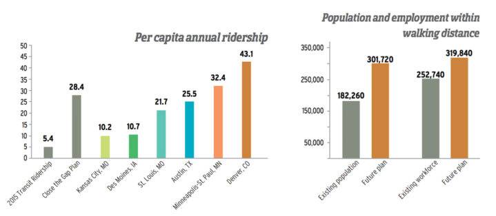
These transit corridors capture the densest concentrations of residents and employees in the region, with hundreds of thousands who live or work within walking distance (1/4 mile) of the corridors. With enhanced transit service and accelerated redevelopment along these corridors, these numbers will increase dramatically as our region grows.
Today, Metro’s system averages 15,000 riders per day. With Bus Rapid Transit (BRT) installed along the corridors, the system would increase ridership dramatically along the corridors to an estimated 62,000 riders per day by 2040, more than four times the system’s total current ridership. Another scenario tested as part of our plan extended the proposed Streetcar westward as a Light Rail (LRT) line that connects UNMC to Aksarben Village, continuing westward along the West Center corridor to Oak View Mall near 144th Street. This line would attract 15,000 trips per day in 2040, and together with the BRT lines would result in more than 90,000 riders per day by 2040. This level of ridership would place the Omaha-Council Bluffs region’s transit on the level of larger regions such as St. Louis, Austin, and Minneapolis-St. Paul.
The accelerated development tested in these scenarios is critical to the success of all these corridors– bringing more people, destinations, and employment opportunities within walking distance of fast and convenient transit service that reduces our reliance on the automobile. A modern streetcar can help achieve this within central Omaha, while a network of walkable neighborhoods and activity centers can make it easier to provide additional transportation options throughout the region as well. With the Close the Gap Plan, we’re continuing the conversation about how our land use decisions support transit investments and help our region grow in a way that helps maintain the quality of life that residents desire.
Check out www.heartland2050.org for more information on the Heartland 2050 project and the Close the Gap Plan.